What is GIS (Geographic Information Systems)
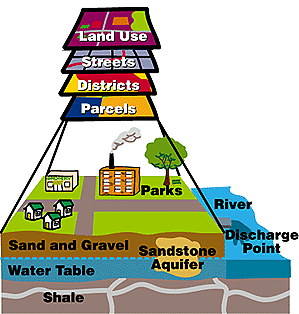
The Geographic Information System (GIS) is a computer system that is used to construct, record, analyze, manipulate, and display geographic information. Geographic information is simply any data that is geographically referenced or that has known earth coordinates(i.e. Latitude/Longitude)
Features such as points(e.g. wells, street signs), lines(e.g. roads, rivers) and polygons(e.g. houses, crop fields) can be created in a GIS and coordinated with other databases into one large GIS, and then queries and decisions can be made on the entire GIS or specific elements depending on the desired application.
GIS Applications :
Retail
Most new out-of-town supermarkets are sited with the aid of a sophisticated GIS. The GIS is used to store socioeconomic details of possible customers within the proposed area. A catchment area for a store may be developed by calculating the drive-time - the time it would take to drive to the store's location - and by modeling the influence of competing stores. GIS is also used for facilities management and routing of deliveries.
Utilities
The utility companies are amongst the most active GIS users; GIS is used to build asset databases which often form a central part of their IT strategies. Vector GIS commonly dominates in this sector, extensive use being made of modeling functions which are used to test the response of the network to demand fluctuations. The largest application in utilities is in the area of Automated Mapping and Facilities Management (AM/FM). AM/FM functions are used to manage the plant of the organization, such as the location of cables, valves, customer boxes etc. This application demands up to the minute accurate large scale mapping in digital form.
Environment
As some of the earliest users of GIS, there are many mature applications within organizations interested in environmental data. At the simplest level GIS is used as an inventory of environmental information, for example the location and attributes of forest stands. More complex applications use the analytical capabilities of GIS to model environmental processes such as soil erosion, or the response of a river basin to a large rainfall event. As the data collected often relates to areas and complex analytical functions are common, the raster data model tends to predominate.
Local Government
Local government is one of the largest application areas for GIS, as it is one of the largest users of spatial information. All areas of a local authority may benefit from GIS. GIS may be used in land searches and planning control, replacing existing paper records. Local authorities may also use GIS for property and highways maintenance. GIS may be used in command and control centres for monitoring the emergency services.
Health care
In addition to the asset management tasks in which GIS is commonly used, the analytical capabilities of GIS may also be used in health care applications. GIS may be used, for example, to identify the fastest route between the current location of an ambulance and a patient, based on a database of road conditions. GIS can also be used as an epidemiological tool to analyse the outbreak and spread of illness and disease within the community.
Transportation
GIS has considerable potential for applications in transportation. The planning and maintenance of a transport infrastructure is an obvious application area, but there is now increasing interest in innovative technology such as in-vehicle navigation, and electronic chart displays. These typically require GIS in a support role.
Financial Services
GIS is used in the financial services sector in much the same way as in retail applications. It is used to locate new branches of Banks and Building societies. GIS is increasingly being used as a profiling tool for risk assessment and insurance purposes, identifying in greater detail those areas of highest/lowest risk. This requires databases as diverse as crime patterns, geology, weather and property values.
Source : Google ,Wikipedia ,University of California & many research articles.

Comments
Post a Comment